360VR Camera Rig for interior tours & drone flight

outdoor indoor 360vr vr video photo maryland.

360VR Camera Rig for interior tours & drone flight

SkyeCam Studios 3D 360VR VR video and photo tours better than matterport in Baltimore MarylandSkyeCam Studios has a professional-level, 360 degree 6 camera-array set-up for spherical 360 video and photo capture. Our spherical rig captures 8K video and 50 megapixel photo-spheres.

We can fly the camera set-up by drone or we can bring it on ground in the house for a realistic immersive tour.

We perform better than Matterport as they charge Cloud fees, Cloud rendering fees, and Cloud hosting fees, which we do not. In addition, Matterport does not allow for 360 video, which we do beautifully.

With the ability to fly a 360 camera VR rig, we enable the user to look at anything they want as the camera is flying- a truly stunning sight to see to see an aerial view of.

Additionally, we are registered with Google Street View and can submit interior and exteriors as we are a Google Street View Trusted business.

All of the content we make is fully immersive – you can use it with a head-mounted display such as the Oculus Rift, the HTC Vive, Google Daydream, the Samsung Gear VR or something as simple as Google Cardboard.

We also do the full rendering experience for properties that are not built yet and are looking to presell, develop or advertise with our team of architects, interior designers and game designers. This content can also be viewed on a multitude of applications and even allows the user to change flooring options, wall colors, pick-up items, turn-on-off lights, or anything else you can dream of.

Check out our article for more information on our VR rendering process. You can contact our Baltimore, Maryland office at 443-470-9001.


Baltimore County City Howard Maryland Aerial Prints for Hire for sale SkyeCamProductions

High Quality Aerial Drone Stock Photography and Prints

Baltimore County City Howard Maryland Aerial Prints for Hire for sale SkyeCamProductionsDue to frequent demand, SkyeCamStudios is now offering customers the ability to purchase stock photography of media listed in the portfolio and elsewhere.

Keep in mind that not all of our aerial drone photographs are listed on the website so if you have a specific request that you do not see, feel free to ask. Additionally customers now have the option to purchase customized digital prints of our aerial drone photographs either on canvas or other available mediums.

These photographs will be edited specifically for large format printing and delivered to you directly or to a nearby retail partner. If for some reason the specific photograph you are looking for does not exist we would be more than happy to drone it for you at our everyday affordable rate and in a timely fashion.

These custom prints are a perfect way to showcase the beauty of Maryland or your property.


  • -

The Positive Future of Drones and Aerial Photography

Aerial Photography Baltimore Maryland

As the Federal Aviation Administration (FAA) works to meet its September 2015 deadline to decide on the future of unmanned aerial vehicles (UAVs), also known as multi-copters or “drones,” it is time to gaze into the future of a near certain multi-billion dollar industry.
Although drones often have the negative connotation as military killers, their most important application is on the home front as versatile tools, providing not only affordable alternatives in the world of aerial photography but also  offering applications in a number of previously untouched fields. Let’s take a look at how drones could shape the world in a positive way.

Farming

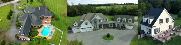
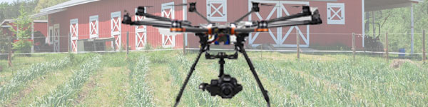
Every day unnecessary amounts of water, pesticides and other crop inputs are wasted because of inefficient aerial technology leading to thousands of wasted dollars and total crop loss. Drones would provide farmers a fully automated tool to not only accurately give crops the nutrients they need but also to offer aerial photography and video essential to assessing the status and growth of a harvest and lowering the environmental impact of excessive spraying of pesticides. Planes and helicopters are a very inaccurate and expensive tool that can cost up to $1,000 an hour to operate. With an expanding global population trending towards 10 billion, it is essential we transition to efficiency in agriculture by implementing commercial drone technology.

Search and Rescue

Recently a news story emerged about a missing 82-year-old man with dementia in the woods in Virginia. After days of helpless ground searching and helicopter searching, he was found with the help of an amateur drone pilot using first person perspective aerial imagery. This resource provides a much more efficient alternative to on the ground searching, which often requires large numbers of flashlight wielding volunteers and others inefficiently wandering through unnavigable terrain. Organizations are already popping up like the nonprofit Texas EquuSearch. Unfortunately, the FAA is pressuring the organization to stop, despite being involved in nearly 1,500 searches and having successfully found 300 missing persons since its inception. As regulation and restrictions open up, aerial drones will provide an excellent resource to a commonly occurring challenge.

Humanitarian Aid

Earlier this year, a joint MIT-Harvest Health and Sciences project won a $100,000 grant from Bill Gates’ foundation that will allow the researchers to develop drone technology capable of delivering vaccine and medical supplies to the most remote locations on the planet. Other groups such as Matternet in Silicon Valley are working on similar endeavors that will allow suppliers to reach areas inaccessible by roads.

Package and food delivery

Amazon has already announced its new offering called Amazon Air that promises to deliver packages directly to homes in Dominos-esque fashion, 30 minutes or less. They are not the only ones looking forward to using drone technology to allow the transport of goods. A Bay Area startup announced plans to deliver food with its so called “Taco-copter,” but until the FAA establishes rules for such controversial business designs, none of these types will be possible. They do however shine a light into a world of possibilities using drones as delivery mechanisms.

It would be impossible to touch on the never-ending list of realistic possibilities with this technology in the future. Hopefully this article opens minds to see the future of drone technology is not merely limited to aerial photography hobbyists.
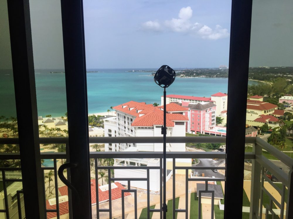

Benefits of Aerial Photography for Real Estate in Maryland

Baltimore Maryland Aerial Photography Shot With Drone By Skycam Studios

As the modern home-buyer has evolved into a digital shopper, with statistics from ‘Digital House Hunt’indicating that 90% of home buyers have searched online during the home buying process and 28% have used their mobile phones, it is very clear that high quality photography is an essential component to selling real estate.

Benefits in the Air

Unfortunately regular ground photography is incapable of showcasing luxury property to its highest potential. For years real estate agents have patched this issue by resorting to aerial photography services reliant upon helicopter and small aircraft. Not only is this option very impractical economically but additionally the photographs and video taken are limited by poor stabilization, elevation and space inflexibility (these types of aircraft are incapable of flying at low altitudes and over certain terrain) and time. The birth of the drone has resolved the main issues with aerial photography for real estate by providing higher quality photography and video at a fraction of the cost of the previously available services.

Minutes to Takeoff

Within minutes of arriving at the location of a house, the drone can be airborne, perform multiple takes of a shot without being constrained by a limited fuel time, and reach any angle or altitude desired by the agent. Maryland is a place of beauty with homes that deserve to be showcased properly. We are able to travel nationwide.

Contact us

Contact us today and let us be your aerial photography and video specialists! We know what it takes to promote and sell your property the right way.


  • -

Indoor Drone Photography in Maryland

Indoor Photography In Baltimore Maryland Using Aerial Drones From Skyecam Studios

With the newest additions to our Baltimore drone fleet, SkyeCam Studios now has the ability to safely perform indoor aerial drone flights for both photos and video. Our drones have the ability to shoot sonic waves to the ground, which in addition of a downward facing camera help to map out the area below for safe flying indoors. This has previously been impossible to achieve safety as previous drone models rely on satellite signals to navigate with and they do not function well indoors.

The Technology

We have a fleet of these drones in Baltimore, Maryland ready to fly both indoors and outdoors. An example of drone use indoors is a video mapping out a home or a commercial real estate location. The shots are silky smooth as the camera is fully independent and stabilized. All video is filmed in Ultra HD, also known as 4K. The advantage of flying indoors is that we can position a camera at any angle.

Indoor Ground Photography Service

Additionally, another dual option service we have not previously mentioned on the website, but have frequently provided for real estate clients is indoor real estate photography. These indoor images of the property are captured with a high quality ground camera separate from the drone, all during the same visit to the home. We are able to your one stop shop providing real estate services room to room as well as drone exteriors.


  • -

Aerial Cinematography: Our Experience in Drone TV Production

Aerial Cinematography Shot By Skycam Productions

Slowly and steadily drones are transcending helicopters, dollies, and other traditional models of simulated flight in the world of aerial cinematography. The economic feasibility, camera angle flexibility and rapid setup time of drones prove them to be the real winner in TV and film production.

The Plot

We recently had the honor of filming with Discovery Communications’ “American Hero’s Channel” (previously titled the Military Channel). The journey began in rural Gettysburg, Pennsylvania set in a backdrop of heavy forest in order to mimic the dense jungle environment present in Vietnam during the war. The plot of the shoot revolved around an American helicopter hero pilot who provided crucial medical aid and advanced recon that aided in the rescue of a group of American soldiers caught in the thick of battle.

New Technologies

With our drone and the addition of heavy duty fans we were able to emulate the idea of a moving helicopter hovering and delivering medical supplies to American soldiers. The producer will take the footage and use a blue screen to sell the viewer the idea that it is identical. This set would have been impossible to replicate using a real helicopter for reasons of safety due to the heavy foliage present and exponentially more expensive with a production level dolly or jib. Another important advantage the drone has in production is that most multi-rotor flying cameras do not require gas, instead rely on rechargeable batteries that are capable of being switched out within a moment’s time allowing multiple retakes with ease. Oftentimes the sound recorded on a set is important to maintain and a drone is considerably less noisy than a helicopter. Because the drone is wirelessly transmitting the video feed to LCD monitors on the ground, the producer is able to frame the desired shot precisely as he or she desires.

Our Future

We eagerly anticipate our next adventure in the world of aerial cinematography as the world of drones take effect.